Scope
The Konya Regional Archaeological Project (KRASP) is an interdisciplinary research program co-directed by Michele Massa (Bilkent University) and Christoph Bachhuber (University of Oxford), in close collaboration with Fatma Şahin (Çukurova University) and James Osborne (University of Chicago). KRASP is developing a synthetic, interdisciplinary approach to the archaeological landscapes of the Konya Plain (central Turkey, Figure 1), from the Aceramic Neolithic to the end of the Iron Age (about 9000-300 BC). The region, home to the UNESCO World Heritage Site of Çatalhöyük, is one of the largest and most fertile plains in Türkiye, with a 10,000-year history of sedentary settlement and agropastoral communities.
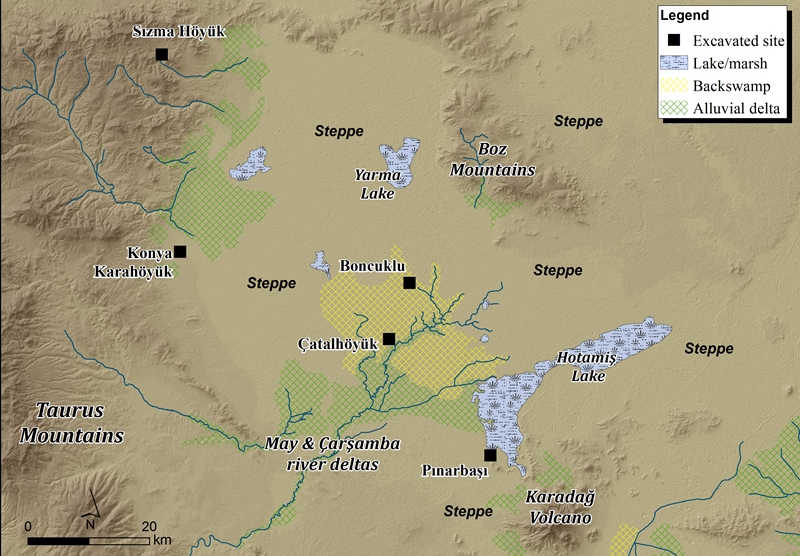
Over the last century the region has been the focus of numerous palaeo-environmental studies, excavations and survey projects which have focused primarily on the alluvial ecosystem of the Çarşamba and May river deltas. One of the primary aims of KRASP is to survey the neglected eastern region of the Plain (within the Çumra and Karatay districts), defined mostly by “marginal” steppe and highland landscapes.
Aims
By synthesizing and reassessing results of decades of previous research in combination with new data from KRASP’s surveys, the Konya Plain provides an ideal regional context to address fundamental developments that have been largely neglected in Anatolian archaeology. Longue dureé processes of sedentism, urbanism and political consolidation (and collapse), and related phenomena such as modifications to landscapes, farming production, and pastoral mobility, are all being investigated from a regional perspective. With these issues in mind, KRASP brings together an international team of specialists to achieve two overarching goals:
- to understand human-environment interactions in different ecological niches (alluvium, steppe, highlands), and under varying socio-economic and political conditions;
- to shed light on the different forms of socio-cultural, economic and political interaction between communities in the Plain and with the neighbouring areas.
Relevant research towards our first goal includes assessing potential long-term impacts of land management on the different ecoystems of the Konya Plain, including farming, deforestation and resource exploitation. The relationship between irrigation and the formation of larger state-like entities is a core concern of KRASP. We are also addressing the relationship between climate-induced environmental changes and broader patterns of settlement in the Konya Plain, for example through consideration of relatively sudden shifts in rainfall regimes and average temperatures that appear to correlate with the end of the Neolithic (the 8.2ka event), the Early Bronze Age (the 4.2ka event) and the Late Bronze Age (the 3.2ka event).
Relevant research towards our second goal includes understanding the causes and effects of interaction within and beyond the Konya Plain, for example as mediated by resource procurement networks and political consolidation. We are also exploring how emergent polities defined themselves spatially, whether through the construction of fortified hilltops or the commissioning of landscape monuments. More broadly, KRASP is providing a landscape and regional perspective on spatially extensive phenomena such as the onset (and collapse) of urban settlements and state-like polities.
Türkmen-Karahöyük
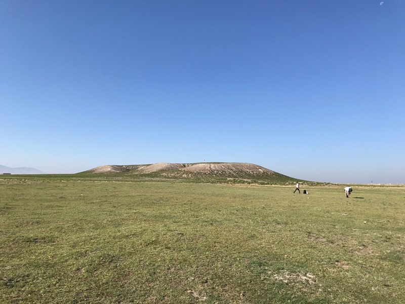
In particular, since 2019 the project has in part focused on Türkmen-Karahöyük, a major archaeological site (Figure 2) with an occupation spanning approximately the end of the Late Chalcolithic to the late Hellenistic periods (ca 3500-30 BCE). Material remains indicate that Türkmen-Karahöyük was an important regional centre from the early 2nd to the latest 1st millennia BCE. For the Late Bronze Age, large quantities of North Central Anatolian-style pottery, small votive bowls, Egg-shell ware, Red Lustrous Ware and a fragment of a Hittite figurine point to the presence of a major Hittite administrative centre. In addition, its location within the Çarşamba river delta (identifiable with the Hittite “Hulaya river”) and its connection with the Karadağ volcano, home to a sanctuary of the celestial Storm-God Tarhunta, make the equation between Türkmen-Karahöyük and Tarhuntassa (lit. “City of Tarhunta”) entertainable.
Hieroglyphic inscription at the site
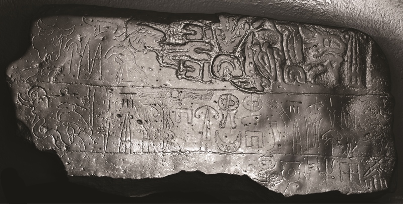
The discovery of the TÜRKMEN-KARAHÖYÜK 1 Luwian Hieroglyph inscription of Great King Hartapu (Figure 3) also proves the existence of a hitherto unknown Middle Iron Age kingdom based in the Konya Plain and contemporary with other kingdoms in the region of Tabal, Phrygia and the Neo-Assyrian Empire (ca 750 BCE). Its retrieval at Türkmen-Karahöyük suggests that the site may have been Hartapu’s capital. Other Hartapu inscriptions are known from the immediate vicinity of the site, namely at the peak sanctuaries of Karadağ and Kızıldağ 13 and 26km away, respectively.
Under the aegis of Bilkent University, an excavation project at the site took place in summer 2023.